
'Domeng' now a tropical storm; No warning signal raised

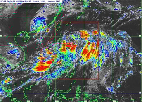
CYCLONE "Domeng" (Maliksi) intensified into a tropical storm while moving northeast Friday, June 8, said the state weather bureau in an advisory.
As of 10 a.m. Friday, the center of the tropical storm was located at 655 kilometers east of Tuguegarao City in Cagayan province, packing maximum winds of 65 kilometers per hour (kph) near the center and gusts of up to 89 kph.
No tropical cyclone warning signal has been raised so far.
The Philippine Atmospheric, Geophysical and Astronomical Services Administration (Pagasa) said in its 11 a.m. bulletin that Domeng will continue to move north northeast at 17 kph.
Pagasa said the combined effects of Domeng and the Southwest Monsoon (Habagat) "will bring moderate to occasional heavy rains over Aurora, Bataan and the regions of Bicol, Calabarzon, Mimaropa, and Western Visayas," adding that it will also bring scattered rainshowers over the rest of Luzon and Visayas today, June 8.
"DomengPH is expected to enhance the Southwest Monsoon, which may bring monsoon rains over Metro Manila and the rest of western sections of both Luzon and Visayas this weekend," it added.
The weather bureau advised the residents in the areas mentioned above to take appropriate actions against possible flash floods and landslides and coordinate with their local disaster management offices.
"Sea travel is risky over the eastern seaboard of Central and Southern Luzon and of Visayas, and the western seaboard of Southern Luzon," Pagasa said. (LMY/SunStar Philippines)