

THE government has tasked the National Disaster Risk Reduction and Management Council to prepare and coordinate with its local offices to ensure public safety as Tropical Depression Odette continued to move toward the country.
In a statement Monday, December 13, Cabinet Secretary and acting presidential spokesperson Karlo Nograles said the government is closely monitoring Odette, which according to weather forecasters, will likely enter the Philippine area of responsibility as a severe tropical storm on the evening of December 14.
“The Department of Social Welfare and Development reports that as of Sunday, December 12, it has available stockpiles and standby funds earmarked for disaster response,” he said.
He asked the public “to keep up to date with the latest weather advisories and bulletins, to take precautionary measures, and to cooperate with local authorities should there be a need for evacuation or other necessary actions.”
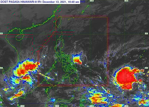
Odette, according to the Philippine Atmospheric, Geophysical and Astronomical Services Administration (Pagasa), has maintained its strength as it continued to move westward.
As of 10 a.m. Monday, December 13, the center of the tropical depression was located at 1,760 kilometers east of Mindanao, still outside PAR. It has maximum sustained winds of 55 kilometers per hour (km/h) near the center, gusts up to 70 km/h, and central pressure of 1002 hPa.
Odette was moving westward at 10 km/h.
With its speed, the tropical depression was forecast to enter the PAR as a severe tropical storm Tuesday evening, December 14, and its west northwestward movement was forecast to continue until Wednesday morning (December 15.
“Afterwards, the tropical cyclone will turn westward and may make landfall in the vicinity of Caraga or Eastern Visayas by Thursday (16 December) afternoon or evening,” said Pagasa.
The weather bureau also forecast Odette to gradually intensify within the forecast period and may reach typhoon category by Wednesday, December 15.
A peak intensity of around 150 km/h may be reached prior to landfall, it added.
“Current track and intensity forecast shows that there is a high likelihood that Tropical Cyclone Wind Signals will be hoisted for Visayas, large portions of Mindanao, and several provinces in Southern Luzon due to the threat of strong to typhoon-force winds,” said Pagasa.
It added that the highest possible wind signal that may be hoisted is TCWS Number 3.
“Localities situated in the eastern portions of Visayas and Mindanao may be placed under TCWS #1 as early as Tuesday afternoon or evening,” it said.
The agency warned the public about heavy rainfall over Visayas, large portions of Mindanao, and several provinces in Southern Luzon during the passage of Odette over the central portion of the archipelago.
It also warned residents of coastal inundation due to high waves near the coast and storm surge, which Pagasa said is possible for low-lying localities near and along the path of the typhoon. (LMY)