
TYPHOON Malakas has entered the Philippine area of responsibility (PAR) and was named “Basyang,” the Philippine Atmospheric, Geophysical and Astronomical Services Administration (Pagasa) said Tuesday, April 12, 2022.
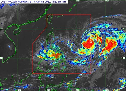
Pagasa said Basyang was spotted at 1,435 kilometers east of Southern Luzon as of 10 a.m. Tuesday, with maximum sustained winds of 120 kilometers per hour (km/h) near the center, gusts of up to 150 km/h, and central pressure of 975 hPa.
Basyang was moving north northwestward at 20 km/h with strong winds that may extend outwards up to 600 kilometers from the center.
The weather bureau said the duration of the typhoon within the PAR will be brief, as it may exit Tuesday evening, April 12.
Pagasa said the weather system is unlikely to directly affect the weather and sea condition in the country.
“However, swells resulting from this tropical cyclone is forecast to generate moderate to rough seas over the northern and eastern seaboards of Luzon and the eastern seaboards of Visayas and Mindanao,” it said.
“These conditions may be risky for those using small seacrafts. Mariners are advised to take precautionary measures when venturing out to sea and, if possible, avoid navigating in these conditions,” it added.
Meanwhile, in its 11 a.m. Tuesday update, Pagasa said the southern portion of Masbate (Dimasalang, Cawayan, Palanas, Placer, Cataingan, Esperanza and Pio V. Corpuz), Eastern Samar, Samar, Northern Samar, Biliran, Leyte, Southern Leyte, the northeastern portion of Cebu (Daanbantayan, Medellin, City of Bogo, Tabogon, Borbon and Sogod) including Camotes Island and Dinagat Islands remained under Tropical Cyclone Warning Signal Number 1 due to Tropical Depression Agaton (Megi).
The center of Agaton was last spotted over the vicinity of Marabut, Samar with maximum sustained winds of 45 km/h near the center, gusts of up to 75 km/h, and central pressure of 1000 hPa.
Agaton continued to move slowly eastward with strong winds or higher that extend outwards up to 150 kilometers from the center.
Agaton continue to cause moderate to heavy with at time intense rains over Eastern Visayas, Bicol Region, the northern and central portions of Cebu including Bantayan and Camotes Islands, Aklan, Capiz, Iloilo, Antique, Guimaras, and the northern and central portions of Negros Provinces, as well as light to moderate with at times heavy rains over Mimaropa, Dinagat Islands, Zamboanga del Norte, Quezon, and the rest of Visayas.
Pagasa said Agaton was forecast to deteriorate into a remnant low within the next 24 hours as it becomes assimilated within the circulation of Basyang.
The National Disaster Risk Reduction and Management Council (NDRRMC) said a total of 4,681 families or 17,070 individuals have already been displaced in areas battered by Agaton.
It said a total of 139,146 individuals or 95,741 families from 274 barangays in Bicol, Western Visayas, Central Visayas, Eastern Visayas, Northern Mindanao, Davao Region, Soccsksargen, Caraga and Bangsamoro were affected by the weather system.
The NDRRMC said they are still verifying the 20 casualties of Agaton that were earlier reported by their regional offices.
It said some of the regions were experiencing power outages, flooding and landslides due to the effects of Agaton.
A total of 84 houses, P874,000 worth of agriculture products and P250,000 infrastructure were reported damaged amid the onslaught of Agaton.
The Philippine Coast Guard said almost 7,000 individuals were still stranded in various ports as sea travels were cancelled due to bad weather.
The National Government earlier ensured the provision of assistance to the Agaton-affected population. (SunStar Philippines)