
Third Anne Peralta-Malonzo
THE Office of the Civil Defense (OCD) has prepositioned over P108 million worth of non-food relief items in its regional offices in preparation for the onslaught of Super Typhoon Betty (international name: Mawar).
In a statement, Civil Defense Administrator and National Disaster Risk Reduction and Management Council (NDRRMC) Executive Director Undersecretary Ariel Nepomuceno said the OCD also has a standby Quick Response Fund (QRF) for 2023 amounting to P256.2 million and a continuing QRF from last year worth P244.7 million.
“All these are ready for distribution to assist the affected communities. Other resources of the government are also on standby including our equipment for emergency telecommunications, transportation assets, among others,” Nepomuceno said.
He said the Department of Social Welfare and Development (DSWD) has a total of P2.2 billion worth of stockpile in its Central office, field offices, and National Resource Operations Center (NROC).
Nepomuceno said emergency preparedness and response (EPR) protocols of the NDRRMC are now activated in different parts of the country, especially those along the track of the weather system.
He said a total of 1,679 teams from the Armed Forces of the Philippines (AFP), Philippine National Police (PNP), Bureau of Fire Protection (BFP), and Philippine Coast Guard (PCG) are on standby for search, rescue and retrieval.
“We continue to coordinate with different agencies on preparations for Super Typhoon ‘Betty.’ This is to ensure that all necessary measures are in place from the national down to the local level,” said Nepomuceno.
“We have already identified and activated appropriate emergency preparedness and response protocols in different regions to be affected by the weather disturbance,” he added.
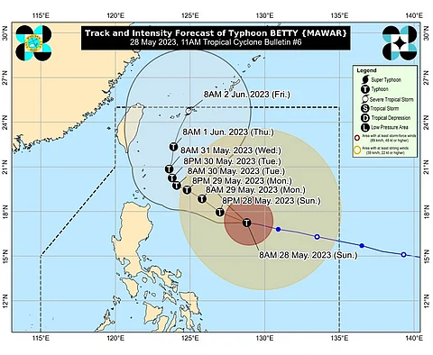
As of 10 a.m. Sunday, the Philippine Atmospheric, Geophysical and Astronomical Services Administration (Pagasa) said the center of Betty was spotted at 715 kilometers east of Tuguegarao City, with maximum sustained winds of 175 kilometers per hour (km/h) near the center, gustiness of up to 215 km/h, and a central pressure of 935 hPa.
The weather bureau said Betty was moving westward at 15 km/h.
It warned of strong winds in the next 36 hours, posing minimal to minor threat to life and property in the areas under Tropical Cyclone Wind Signal No. 1 including:
*Batanes
*Cagayan including Babuyan Islands
*Isabela
*Apayao
*Ilocos Norte
*the northern and central portions of Abra (Tineg, Lacub, Lagayan, San Juan, Lagangilang, Licuan-Baay, Malibcong, Danglas, La Paz, Dolores, Tayum, Bucay, Sallapadan, Daguioman, Bucloc, Boliney)
*Kalinga
*the eastern and central portions of Mountain Province (Sadanga, Barlig, Natonin, Paracelis, Bontoc)
*the eastern and central portions of Ifugao (Mayoyao, Aguinaldo, Alfonso Lista, Banaue, Hingyon, Lagawe, Lamut, Kiangan, Asipulo)
*the northern and central portions of Aurora (Dilasag, Casiguran, Dinalungan, Dipaculao)
*Quirino
*the northeastern portion of Nueva Vizcaya (Kasibu, Quezon, Solano, Bagabag, Diadi, Villaverde, Bayombong, Ambaguio)
Betty is expected to bring rains on Monday until Tuesday or Wednesday morning in the eastern portion of Babuyan Islands and the northeastern portion of mainland Cagayan, Batanes, the northwestern portion of mainland Cagayan, and the northern portions of Ilocos Norte and Apayao.
Pagasa said monsoon rains are possible over the western portions of Mimaropa and Western Visayas by Monday; over the western portions of Calabarzon, Mimaropa, and Western Visayas on Tuesday and over Western Visayas and the western portions of Central and Southern Luzon on Wednesday.
“Under these conditions, flooding and rain-induced landslides are likely, especially in areas that are highly or very highly susceptible to these hazard as identified in hazard maps and in localities that experienced considerable amounts of rainfall for the past several days,” it said.
“'Betty' will move west-northwestward or northwestward until tomorrow while gradually decelerating. The typhoon will likely become slow-moving to almost stationary by Tuesday while over the waters east of Batanes. It will then move northward or north-northeastward by mid Wednesday or Thursday towards the sea east of Taiwan,” it added. (SunStar Philippines)