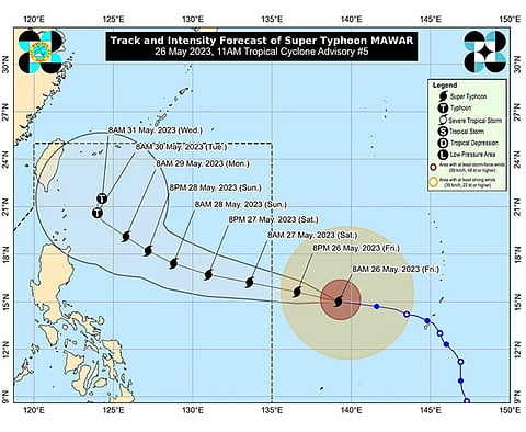

SUPER Typhoon Mawar slightly intensified as it moved westward over the Philippine Sea Friday morning, May 26, 2023, said the state weather bureau.
As of 10 a.m. Friday, the eye of the tropical cyclone was located at 1,705 kilometers east of southeastern Luzon, with maximum sustained winds of 215 km/h near the center, gusts of up to 260 km/h, and central pressure of 905 hPa.
The Philippine Atmospheric, Geophysical and Astronomical Services Administration (Pagasa) said that Mawar was moving west at 20 km/h, and strong to typhoon-force winds that it is packing may extend outwards up to 550 kilometers from the center.
Pagasa said Mawar was forecast to enter the Philippine area of responsibility (PAR) Friday night, May 26, or early morning of Saturday, May 27.
The super typhoon was also forecast to track generally west northwestward until Sunday, May 28, while accelerating before turning northwestward on Sunday.
“Mawar will begin to decelerate on Sunday as it begins to move closer towards the waters east of extreme northern Luzon. The center of Mawar’s eye is forecast to be within 250 kilometers of the Batanes-Babuyan archipelago by next week during the slowdown period,” said the weather bureau.
Pagasa added that Mawar will reach its peak intensity within 24 hours.
“The super typhoon may slightly weaken by tomorrow evening but is expected to remain as a super typhoon until Monday morning due to highly favorable environment,” it said.
By late Monday or Tuesday, Mawar was expected to weaken at a slightly faster rate due to unfavorable conditions (e.g., increasing wind shear, cooler sea surface temperature resulting from its slowdown by that time, and dry air intrusion).
Pagasa warned residents in northern Luzon against heavy rains that may trigger flooding and landslides beginning late Sunday or on Monday next week.
It said that strong to storm-force conditions may be experienced over extreme northern Luzon, while strong to gale-force conditions are possible over the northern and eastern portions of northern Luzon mainland.
“As a result, wind signals will be raised by tomorrow evening in preparation for these severe winds,” said Pagasa.
Residents in central and southern Luzon and Visayas were also warned against monsoon rains beginning on Sunday or Monday, as Mawar was expected to enhance the Southwest Monsoon. (LMY)